
EARTH’S INTERIOR
Introduction
The Earth is not a solid, uniform ball. It is built in layers, like an onion, and each layer differs in composition, temperature, pressure and density. The surface we live on is only the outermost, thinnest skin of this structure.
No one has ever seen the deep interior. The deepest hole ever drilled is about 12 km, while the centre of the Earth lies about 6,371 km down. Scientists therefore rely mainly on seismic waves, along with temperature, pressure, gravity, magnetism and meteorites, to work out what lies below.
Important facts
Fact |
Value |
| Mean radius of Earth | about 6,371 km |
| Age of Earth | about 4.5 billion years |
| Average density of Earth | 5.5 g/cm³ |
| Deepest mine | Mponeng gold mine, South Africa (about 4 km) |
| Deepest drilling | Kola Superdeep Borehole, Russia (about 12 km, drilled by the Soviet Union in the 1970s–80s) |
Sources of Information About the Earth’s Interior
Humans cannot go deep inside the Earth, so scientists use two kinds of sources.
1. Direct Sources
These give actual samples of rock, but only from shallow depths.
- Mining: Deepest mines reach only about 3.9–4 km (Mponeng and TauTona, South Africa).
- Drilling: Kola Superdeep Borehole (Russia) is the deepest, about 12 km. Other projects include the Deep Ocean Drilling Project and the Integrated Ocean Drilling Program.
- Volcanic eruptions: Magma (molten rock below the surface) becomes lava on reaching the surface and can be studied in laboratories. However, the exact depth of its source is hard to determine.
2. Indirect Sources
These help us understand the full structure of the Earth.
- Increase of temperature, pressure and density with depth: Calculated using the Earth’s size and gravity.
- Seismic waves: The most important and reliable source for the layered structure.
- Meteorites: Formed from the same nebular material as the Earth. Iron-nickel meteorites resemble the core.
- Gravity anomalies: Differences in gravity from expected values show how mass is distributed in the crust.
- Magnetic surveys and the magnetic field: Reveal magnetic materials in the crust and the activity of the iron core.
Sources of Earth’s Heat
Temperature rises with depth. The main sources of internal heat are:
- Radioactive decay (uranium, thorium, potassium) in the crust and mantle: provides the largest share, more than half of Earth’s heat.
- Primordial heat: Left over from the formation of the Earth (impacts of meteorites and comets, friction from heavy iron sinking to the centre).
- Tidal friction: Gravitational pull of the Moon and Sun flexes the solid Earth, producing a small amount of heat. This also slows Earth’s rotation very slightly.
Temperature, Pressure and Density with Depth
Property |
Trend |
Key values |
| Temperature | Increases with depth (rate is not uniform; about 15–30°C per km in the upper 100 km) | About 1,000°C at base of crust; about 3,500°C at base of mantle; about 5,000–6,000°C at the centre |
| Pressure | Increases due to the weight of overlying rocks | About 3–4 million times atmospheric pressure at the centre |
| Density | Increases because of pressure and heavier materials | Crust about 2.7–3.0 g/cm³; mantle about 3.3–5.5 g/cm³; core about 10–13 g/cm³ |
Even though the inner core is hotter than the melting point of iron, it stays solid because of the enormous pressure.
Layers Based on Chemical Composition
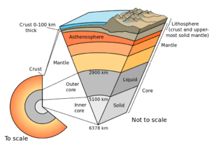
Based on composition, the Earth has three main layers: Crust, Mantle and Core.
The Crust
The crust is the outermost, thinnest and lightest layer. It makes up only about 1% of the Earth’s volume and mass, but almost all known life exists on it.
- Thickness: About 5 km to 70 km. It is thinnest under the oceans and thickest under major mountain ranges (such as the Himalayas).
- Composition: Igneous, sedimentary and metamorphic rocks. Igneous rocks (such as granite and basalt) are the most common.
- Most abundant elements (by weight): Oxygen (about 46.6%), Silicon (27.7%), Aluminium (8.1%), Iron (5%), Calcium, Sodium, Potassium, Magnesium. Memory trick: O-Si-Al-Fe-Ca-Na-K-Mg.
- Most abundant metal in the crust:
- Most abundant element in the crust:
The crust has two types:
Feature |
Oceanic Crust |
Continental Crust |
| Also called | SiMa (Silica + Magnesium) | SiAl (Silica + Aluminium) |
| Main rock | Basalt (mafic and ultramafic) | Granite (felsic) |
| Rich in | Iron and magnesium | Silicon, aluminium and oxygen |
| Thickness | About 5–10 km | About 30–40 km (up to 70 km under mountains) |
| Density | About 2.9 g/cm³ (denser) | About 2.7 g/cm³ (lighter) |
| Age | Younger (less than about 200 million years) | Older (up to about 4 billion years) |
| Position | Lies lower, under oceans | Floats higher on the mantle |
| Formation | From magma rising from the mantle and cooling at the ocean floor | From melting of rocks and accumulation of sediments |
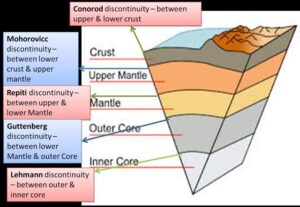
Crust–Mantle Boundary: Mohorovičić Discontinuity (Moho)
- Marks the base of the crust and the beginning of the mantle.
- Seismic wave velocity increases suddenly here because the mantle is denser.
- Discovered by the Croatian seismologist Andrija Mohorovičić in 1909.
- Depth: about 5–10 km under oceans and about 30–40 km (up to 70 km) under continents.
The Mantle
The mantle lies between the crust and the core. It is the largest layer.
- Thickness: About 2,900 km (from the Moho to the core).
- Share: About 84% of the Earth’s volume and about 67% of its mass.
- Density: About 3.3–5.5 g/cm³ (roughly 3.9 g/cm³ on average).
- Composition: Mostly silicate rocks rich in magnesium and iron. Common minerals are olivine, pyroxene and garnet. Peridotite is the major rock type.
- State: Mostly solid but able to flow very slowly over millions of years. Convection currents in the mantle drive plate movement.
- Source of magma: Magma that reaches the surface during volcanic eruptions originates in the upper mantle (the asthenosphere).
Divisions of the mantle
Part |
Depth |
Notes |
| Upper mantle | Moho to about 660 km (includes the transition zone, about 410–660 km) | Contains the asthenosphere. The transition zone stores a large amount of water in its minerals. |
| Lower mantle | About 660 km to 2,900 km | Hotter, denser and more rigid. Its base has a thin region called D” (D-double-prime). |
- Repetti discontinuity: Boundary between the upper and lower mantle (about 660 km).
- Gutenberg discontinuity: Boundary between the mantle and the outer core (about 2,900 km).
The Core
The core is the hot, dense centre of the Earth.
- Radius: About 3,470 km (from 2,900 km depth to the centre at 6,371 km).
- Share: About 33% of the Earth’s mass but only about 16% of its volume.
- Composition: Mainly iron (Fe) and nickel (Ni), hence the name NiFe layer or Barysphere. Small amounts of sulphur, oxygen and silicon are also thought to be present.
- Density: About 10–13 g/cm³.
- Temperature: About 5,000–6,000°C, comparable to the surface of the Sun.
Feature |
Outer Core |
Inner Core |
| Depth | About 2,900–5,150 km | About 5,150–6,371 km |
| Thickness | About 2,200 km | About 1,220 km |
| State | Liquid (molten iron and nickel) | Solid (due to immense pressure) |
| Special role | Generates Earth’s magnetic field through the geodynamo (convection of liquid metal) | Slowly grows as the Earth cools; rotates slightly faster than the surface |
- Lehmann discontinuity (also called the Bullen discontinuity in some books): Boundary between the outer core and inner core (about 5,150 km).
- S-waves do not pass through the outer core, and P-waves slow down and bend there.
Layers Based on Mechanical (Physical) Properties
Based on how rocks behave (rigid or flowing), the Earth is divided into:
Lithosphere
- The solid, rigid outer shell: the crust plus the uppermost mantle.
- Average thickness: About 100 km. It can reach about 200–300 km under old continents and mountain belts, and is thinner (about 50–100 km) under oceans.
- It is broken into large pieces called lithospheric (tectonic) plates, which float and move over the asthenosphere.
- It is the coolest and most rigid part of the Earth.
Asthenosphere
- A hot, weak, ductile and semi-molten layer in the upper mantle, just below the lithosphere.
- Depth: From about 100 km to about 350 km (some books say up to 400 km).
- Called the Low Velocity Zone (LVZ) because seismic wave speeds decrease
- Main source of magma for volcanoes.
- Allows the plates above it to move, which is why it is central to plate tectonics.
Mesosphere (Lower Mantle)
- The strong, more rigid part of the mantle below the asthenosphere, down to about 2,900 km.
Outer Core and Inner Core
- Outer core: liquid. Inner core: solid (as described above).
PYQ
1. What is the purpose of the Earth’s magnetic field? SSC CHSL 03/08/2023 (2nd shift)
(a) To provide an energy source for life on Earth
(b) To control the Earth’s climate
(c) To shield the Earth from solar wind and cosmic radiation
(d) To cause the tides in the ocean
Ans: (c) To shield the Earth from solar wind and cosmic radiation
2. The mohororvicic (Moho) discontinuity separates ? SSC MTS 13/09/2023 (3rd Shift)
(a) Earth’s lithosphere and asthenosphere
(b) Earth’s atmosphere and hydrosphere
(c) Earth’s crust and the inner core
(d) Earth’s crust and the mantle
Ans: (d) Earth’s crust and the mantle.
4. What is the name of the process of gases being outpoured from the interior of the solid earth ? Matriculation Level 26/06/2024 (Shift – 1)
(a) Evaporation
(b) Transpiration
(c) Degassing
(d) Gas evolution
Ans: (c) Degassing
5. How thick is the lithosphere? SSC CGL 03/12/2022 (1st Shift)
(a) 25 to 45 km
(b) 10 to 25 km
(c) 10 to 200 km
(d) 5 to 10 km
Ans: (c) 10 to 200 km.
परिचय
पृथ्वी कोई ठोस और एकसमान गोला नहीं है। इसकी संरचना प्याज की तरह विभिन्न परतों में बनी हुई है और प्रत्येक परत की संरचना, तापमान, दबाव और घनत्व अलग-अलग होते हैं। जिस सतह पर हम रहते हैं, वह इस पूरी संरचना की केवल सबसे बाहरी और सबसे पतली परत है।
पृथ्वी के गहरे आंतरिक भाग को किसी ने प्रत्यक्ष रूप से नहीं देखा है। अब तक किया गया सबसे गहरा ड्रिलिंग छिद्र लगभग 12 किमी गहरा है, जबकि पृथ्वी का केंद्र सतह से लगभग 6,371 किमी नीचे स्थित है। इसलिए वैज्ञानिक पृथ्वी के अंदर क्या मौजूद है, इसका पता लगाने के लिए मुख्य रूप से भूकंपीय तरंगों (Seismic Waves) के साथ-साथ तापमान, दबाव, गुरुत्वाकर्षण, चुंबकत्व और उल्कापिंडों का अध्ययन करते हैं।
महत्वपूर्ण तथ्य
तथ्य |
मान |
| पृथ्वी की औसत त्रिज्या | लगभग 6,371 किमी |
| पृथ्वी की आयु | लगभग 4.5 अरब वर्ष |
| पृथ्वी का औसत घनत्व | 5.5 g/cm³ |
| सबसे गहरी खदान | म्पोनेंग स्वर्ण खदान (Mponeng Gold Mine), दक्षिण अफ्रीका — लगभग 4 किमी |
| सबसे गहरी ड्रिलिंग | कोला सुपरडीप बोरहोल (Kola Superdeep Borehole), रूस — लगभग 12 किमी, जिसे सोवियत संघ द्वारा 1970–80 के दशक में ड्रिल किया गया था |
पृथ्वी के आंतरिक भाग के बारे में जानकारी के स्रोत
मनुष्य पृथ्वी के बहुत गहरे भाग में नहीं जा सकता, इसलिए वैज्ञानिक मुख्य रूप से दो प्रकार के स्रोतों का उपयोग करते हैं।
-
प्रत्यक्ष स्रोत (Direct Sources)
इन स्रोतों से हमें चट्टानों के वास्तविक नमूने प्राप्त होते हैं, लेकिन ये केवल कम गहराई तक की जानकारी प्रदान करते हैं।
- खनन (Mining): सबसे गहरी खदानें केवल लगभग 3.9–4 किमी की गहराई तक पहुँचती हैं। इनमें दक्षिण अफ्रीका की म्पोनेंग (Mponeng) और टाउटोना (TauTona) खदानें शामिल हैं।
- ड्रिलिंग (Drilling): रूस का कोला सुपरडीप बोरहोल लगभग 12 किमी गहरा है और इसे सबसे गहरी ड्रिलिंग माना जाता है। अन्य परियोजनाओं में Deep Ocean Drilling Project और Integrated Ocean Drilling Program शामिल हैं।
- ज्वालामुखीय उद्गार (Volcanic Eruptions): पृथ्वी की सतह के नीचे स्थित पिघली हुई चट्टान को मैग्मा (Magma) कहा जाता है। जब यह सतह पर पहुँचती है, तो इसे लावा (Lava) कहा जाता है। प्रयोगशालाओं में इसका अध्ययन किया जा सकता है। हालाँकि, इसके स्रोत की सटीक गहराई निर्धारित करना कठिन होता है।
-
अप्रत्यक्ष स्रोत (Indirect Sources)
ये स्रोत पृथ्वी की संपूर्ण आंतरिक संरचना को समझने में हमारी सहायता करते हैं।
- गहराई के साथ तापमान, दबाव और घनत्व में वृद्धि: इनका आकलन पृथ्वी के आकार और गुरुत्वाकर्षण के आधार पर किया जाता है।
- भूकंपीय तरंगें (Seismic Waves): पृथ्वी की परतदार आंतरिक संरचना को समझने का सबसे महत्वपूर्ण और विश्वसनीय स्रोत हैं।
- उल्कापिंड (Meteorites): इनका निर्माण उसी नीहारिकीय पदार्थ (Nebular Material) से हुआ माना जाता है जिससे पृथ्वी बनी है। लौह-निकेल (Iron-Nickel) उल्कापिंड पृथ्वी के क्रोड (Core) से समानता रखते हैं।
- गुरुत्वाकर्षण विसंगतियाँ (Gravity Anomalies): अपेक्षित गुरुत्वाकर्षण मानों से होने वाले अंतर से पता चलता है कि पृथ्वी की भूपर्पटी में द्रव्यमान किस प्रकार वितरित है।
- चुंबकीय सर्वेक्षण और चुंबकीय क्षेत्र (Magnetic Surveys and Magnetic Field): इनसे भूपर्पटी में मौजूद चुंबकीय पदार्थों तथा लौह-युक्त क्रोड (Iron Core) की गतिविधियों के बारे में जानकारी मिलती है।
पृथ्वी की ऊष्मा के स्रोत
गहराई के साथ पृथ्वी का तापमान बढ़ता जाता है। पृथ्वी की आंतरिक ऊष्मा के मुख्य स्रोत हैं:
- रेडियोधर्मी क्षय (Radioactive Decay): भूपर्पटी और मेंटल में मौजूद यूरेनियम, थोरियम और पोटैशियम जैसे तत्वों के रेडियोधर्मी क्षय से ऊष्मा उत्पन्न होती है। यह पृथ्वी की आंतरिक ऊष्मा का सबसे बड़ा हिस्सा, अर्थात आधे से अधिक, प्रदान करता है।
- आदिकालीन ऊष्मा (Primordial Heat): यह पृथ्वी के निर्माण के समय से बची हुई ऊष्मा है। इसकी उत्पत्ति उल्कापिंडों और धूमकेतुओं के टकराव तथा भारी लोहे के पृथ्वी के केंद्र की ओर नीचे जाने से उत्पन्न घर्षण से हुई।
- ज्वारीय घर्षण (Tidal Friction): चंद्रमा और सूर्य का गुरुत्वाकर्षण खिंचाव ठोस पृथ्वी में हल्का विरूपण उत्पन्न करता है, जिससे थोड़ी मात्रा में ऊष्मा पैदा होती है। इसके कारण पृथ्वी के घूर्णन की गति भी बहुत थोड़ी कम होती है।
गहराई के साथ तापमान, दबाव और घनत्व
गुण |
प्रवृत्ति |
प्रमुख मान |
| तापमान (Temperature) | गहराई के साथ बढ़ता है। इसकी वृद्धि की दर एकसमान नहीं होती; ऊपरी 100 किमी में यह लगभग 15–30°C प्रति किमी हो सकती है। | भूपर्पटी के आधार पर लगभग 1,000°C; मेंटल के आधार पर लगभग 3,500°C; पृथ्वी के केंद्र पर लगभग 5,000–6,000°C |
| दबाव (Pressure) | ऊपर स्थित चट्टानों के भार के कारण गहराई के साथ बढ़ता है। | पृथ्वी के केंद्र पर लगभग वायुमंडलीय दबाव का 30–40 लाख गुना |
| घनत्व (Density) | अधिक दबाव और भारी पदार्थों की उपस्थिति के कारण गहराई के साथ बढ़ता है। | भूपर्पटी लगभग 2.7–3.0 g/cm³; मेंटल लगभग 3.3–5.5 g/cm³; क्रोड लगभग 10–13 g/cm³ |
यद्यपि आंतरिक क्रोड (Inner Core) का तापमान लोहे के गलनांक से भी अधिक है, फिर भी अत्यधिक दबाव के कारण यह ठोस (Solid) अवस्था में बना रहता है।
रासायनिक संरचना के आधार पर पृथ्वी की परतें
रासायनिक संरचना के आधार पर पृथ्वी की तीन मुख्य परतें हैं—भूपर्पटी (Crust), मेंटल (Mantle) और क्रोड (Core)।
भूपर्पटी (The Crust)
भूपर्पटी पृथ्वी की सबसे बाहरी, सबसे पतली और सबसे हल्की परत है। यह पृथ्वी के आयतन और द्रव्यमान का केवल लगभग 1% हिस्सा बनाती है, लेकिन लगभग सभी ज्ञात जीव इसी पर पाए जाते हैं।
- मोटाई (Thickness): लगभग 5 किमी से 70 किमी। यह महासागरों के नीचे सबसे पतली और प्रमुख पर्वत शृंखलाओं, जैसे हिमालय, के नीचे सबसे मोटी होती है।
- संरचना (Composition): इसमें आग्नेय (Igneous), अवसादी (Sedimentary) और कायांतरित (Metamorphic) चट्टानें पाई जाती हैं। आग्नेय चट्टानें, जैसे ग्रेनाइट और बेसाल्ट, सबसे सामान्य हैं।
- भार के अनुसार सर्वाधिक पाए जाने वाले तत्व: ऑक्सीजन (लगभग 46.6%), सिलिकॉन (27.7%), एल्युमिनियम (8.1%), आयरन (5%), कैल्शियम, सोडियम, पोटैशियम और मैग्नीशियम।
याद रखने की ट्रिक: O-Si-Al-Fe-Ca-Na-K-Mg
- भूपर्पटी में सर्वाधिक पाया जाने वाला धातु: एल्युमिनियम (Aluminium)
- भूपर्पटी में सर्वाधिक पाया जाने वाला तत्व: ऑक्सीजन (Oxygen)
भूपर्पटी के दो प्रकार
विशेषता |
महासागरीय भूपर्पटी (Oceanic Crust) |
महाद्वीपीय भूपर्पटी (Continental Crust) |
| अन्य नाम | SiMa (Silica + Magnesium) | SiAl (Silica + Aluminium) |
| मुख्य चट्टान | बेसाल्ट (Basalt) — मैफिक एवं अल्ट्रामैफिक | ग्रेनाइट (Granite) — फेल्सिक |
| प्रचुर मात्रा में | आयरन और मैग्नीशियम | सिलिकॉन, एल्युमिनियम और ऑक्सीजन |
| मोटाई | लगभग 5–10 किमी | लगभग 30–40 किमी, पर्वतों के नीचे 70 किमी तक |
| घनत्व | लगभग 2.9 g/cm³ — अधिक घनी | लगभग 2.7 g/cm³ — हल्की |
| आयु | अपेक्षाकृत नई — लगभग 200 मिलियन वर्ष से कम | अधिक पुरानी — लगभग 4 अरब वर्ष तक |
| स्थिति | नीचे स्थित, महासागरों के नीचे | मेंटल पर अपेक्षाकृत ऊँची स्थिति में |
| निर्माण | मेंटल से ऊपर उठने वाले मैग्मा के महासागरीय तल पर ठंडा होने से | चट्टानों के पिघलने और अवसादों के संचय से |
भूपर्पटी–मेंटल सीमा: मोहोरोविचिक असंततता (Mohorovičić Discontinuity – Moho)
- यह भूपर्पटी के आधार और मेंटल की शुरुआत को दर्शाती है।
- यहाँ भूकंपीय तरंगों की गति अचानक बढ़ जाती है, क्योंकि मेंटल का घनत्व अधिक होता है।
- इसकी खोज क्रोएशियाई भूकंप विज्ञानी एंड्रिजा मोहोरोविचिक (Andrija Mohorovičić) ने 1909 में की थी।
- गहराई: महासागरों के नीचे लगभग 5–10 किमी तथा महाद्वीपों के नीचे लगभग 30–40 किमी, जो कुछ स्थानों पर 70 किमी तक हो सकती है।
मेंटल (The Mantle)
मेंटल भूपर्पटी और क्रोड के बीच स्थित है। यह पृथ्वी की सबसे बड़ी परत है।
- मोटाई: लगभग 2,900 किमी, अर्थात मोहो से क्रोड तक।
- हिस्सा: पृथ्वी के कुल आयतन का लगभग 84% तथा कुल द्रव्यमान का लगभग 67%।
- घनत्व: लगभग 3.3–5.5 g/cm³, औसतन लगभग 3.9 g/cm³।
- संरचना: यह मुख्य रूप से मैग्नीशियम और आयरन से समृद्ध सिलिकेट चट्टानों से बना है। इसमें पाए जाने वाले सामान्य खनिजों में ओलिविन (Olivine), पाइरोक्सीन (Pyroxene) और गार्नेट (Garnet) शामिल हैं। पेरिडोटाइट (Peridotite) इसकी प्रमुख चट्टान है।
- अवस्था: मेंटल का अधिकांश भाग ठोस है, लेकिन यह लाखों वर्षों के दौरान बहुत धीरे-धीरे प्रवाहित होने में सक्षम है। मेंटल में उत्पन्न संवहन धाराएँ (Convection Currents) टेक्टोनिक प्लेटों की गति को संचालित करती हैं।
- मैग्मा का स्रोत: ज्वालामुखीय विस्फोटों के दौरान सतह तक पहुँचने वाला मैग्मा मुख्य रूप से ऊपरी मेंटल के एस्थेनोस्फीयर (Asthenosphere) से उत्पन्न होता है।
मेंटल के विभाजन
भाग |
गहराई |
प्रमुख विशेषताएँ |
| ऊपरी मेंटल (Upper Mantle) | मोहो से लगभग 660 किमी तक; इसमें लगभग 410–660 किमी का संक्रमण क्षेत्र भी शामिल है | इसमें एस्थेनोस्फीयर स्थित है। संक्रमण क्षेत्र के खनिजों में बड़ी मात्रा में जल संग्रहित हो सकता है। |
| निचला मेंटल (Lower Mantle) | लगभग 660 किमी से 2,900 किमी | यह अधिक गर्म, अधिक घना और अधिक कठोर होता है। इसके आधार पर एक पतला क्षेत्र होता है, जिसे D″ (D-double-prime) कहा जाता है। |
- रेपेटी असंततता (Repetti Discontinuity): ऊपरी और निचले मेंटल के बीच की सीमा, लगभग 660 किमी की गहराई पर।
- गुटेनबर्ग असंततता (Gutenberg Discontinuity): मेंटल और बाहरी क्रोड (Outer Core) के बीच की सीमा, लगभग 2,900 किमी की गहराई पर।
क्रोड (The Core)
क्रोड पृथ्वी का अत्यधिक गर्म और घना केंद्रीय भाग है।
- त्रिज्या (Radius): लगभग 3,470 किमी। यह लगभग 2,900 किमी की गहराई से शुरू होकर पृथ्वी के केंद्र, अर्थात 6,371 किमी की गहराई तक फैला हुआ है।
- हिस्सा (Share): यह पृथ्वी के कुल द्रव्यमान का लगभग 33%, लेकिन कुल आयतन का केवल लगभग 16% है।
- संरचना (Composition): यह मुख्य रूप से लोहा (Fe) और निकेल (Ni) से बना है, इसलिए इसे NiFe परत (NiFe Layer) या बैरीस्फीयर (Barysphere) भी कहा जाता है। इसमें थोड़ी मात्रा में सल्फर, ऑक्सीजन और सिलिकॉन भी उपस्थित माने जाते हैं।
- घनत्व (Density): लगभग 10–13 g/cm³।
- तापमान (Temperature): लगभग 5,000–6,000°C, जो सूर्य की सतह के तापमान के तुलनीय है।
विशेषता |
बाहरी क्रोड (Outer Core) |
आंतरिक क्रोड (Inner Core) |
| गहराई | लगभग 2,900–5,150 किमी | लगभग 5,150–6,371 किमी |
| मोटाई | लगभग 2,200 किमी | लगभग 1,220 किमी |
| अवस्था | तरल — पिघला हुआ लोहा और निकेल | ठोस — अत्यधिक दबाव के कारण |
| विशेष भूमिका | तरल धातु के संवहन से उत्पन्न जियोडायनेमो (Geodynamo) के माध्यम से पृथ्वी का चुंबकीय क्षेत्र उत्पन्न करता है | पृथ्वी के ठंडा होने के साथ धीरे-धीरे इसका आकार बढ़ता है; यह पृथ्वी की सतह की तुलना में थोड़ी अलग गति से घूर्णन करता है |
- लेहमैन असंततता (Lehmann Discontinuity): बाहरी क्रोड और आंतरिक क्रोड के बीच की सीमा, जो लगभग 5,150 किमी की गहराई पर स्थित है। कुछ पुस्तकों में इसे बुलेन असंततता (Bullen Discontinuity) भी कहा जाता है।
- S-तरंगें (S-waves) बाहरी क्रोड से होकर नहीं गुजरती हैं, जबकि P-तरंगें (P-waves) वहाँ पहुँचने पर धीमी हो जाती हैं और उनका अपवर्तन अर्थात दिशा में परिवर्तन होता है।
यांत्रिक (भौतिक) गुणों के आधार पर पृथ्वी की परतें
चट्टानों के व्यवहार, अर्थात वे कठोर हैं या प्रवाहित हो सकती हैं, इसके आधार पर पृथ्वी को निम्नलिखित परतों में विभाजित किया जाता है:
स्थलमंडल (Lithosphere)
- यह पृथ्वी का ठोस और कठोर बाहरी आवरण है, जिसमें भूपर्पटी (Crust) तथा मेंटल का सबसे ऊपरी भाग शामिल होता है।
- औसत मोटाई: लगभग 100 किमी। पुराने महाद्वीपों और पर्वतीय क्षेत्रों के नीचे इसकी मोटाई लगभग 200–300 किमी तक हो सकती है, जबकि महासागरों के नीचे यह अपेक्षाकृत पतला, लगभग 50–100 किमी होता है।
- यह बड़े-बड़े टुकड़ों में विभाजित है, जिन्हें स्थलमंडलीय या टेक्टोनिक प्लेटें (Lithospheric/Tectonic Plates) कहा जाता है। ये प्लेटें एस्थेनोस्फीयर के ऊपर स्थित होकर धीरे-धीरे गति करती हैं।
- यह पृथ्वी का सबसे ठंडा और सबसे कठोर भाग है।
एस्थेनोस्फीयर (Asthenosphere)
- यह स्थलमंडल के ठीक नीचे ऊपरी मेंटल में स्थित एक गर्म, कमजोर, तन्य (Ductile) और आंशिक रूप से पिघली हुई परत है।
- गहराई: लगभग 100 किमी से 350 किमी तक। कुछ पुस्तकों के अनुसार यह लगभग 400 किमी तक विस्तृत हो सकती है।
- इसे निम्न वेग क्षेत्र (Low Velocity Zone – LVZ) कहा जाता है, क्योंकि यहाँ भूकंपीय तरंगों की गति कम हो जाती है।
- यह ज्वालामुखियों के लिए मैग्मा का प्रमुख स्रोत है।
- यह अपने ऊपर स्थित टेक्टोनिक प्लेटों को गति करने की अनुमति देता है। इसी कारण प्लेट विवर्तनिकी (Plate Tectonics) में इसकी महत्वपूर्ण भूमिका है।
मेसोस्फीयर / निचला मेंटल (Mesosphere / Lower Mantle)
- यह एस्थेनोस्फीयर के नीचे स्थित मेंटल का मजबूत और अधिक कठोर भाग है, जो लगभग 2,900 किमी की गहराई तक फैला हुआ है।
बाहरी क्रोड और आंतरिक क्रोड (Outer Core and Inner Core)
- बाहरी क्रोड (Outer Core): तरल (Liquid) अवस्था में होता है।
- आंतरिक क्रोड (Inner Core): ठोस (Solid) अवस्था में होता है, जैसा कि ऊपर वर्णित किया गया है।
पूर्ववर्ती वर्षों के प्रश्न (Previous Year Questions — PYQ)
प्रश्न 1. पृथ्वी के चुंबकीय क्षेत्र (Earth’s Magnetic Field) का क्या उद्देश्य है?
परीक्षा: SSC CHSL, 03/08/2023 (द्वितीय पाली)
(a) पृथ्वी पर जीवन के लिए ऊर्जा का स्रोत प्रदान करना
(b) पृथ्वी की जलवायु को नियंत्रित करना
(c) पृथ्वी को सौर पवन (Solar Wind) और ब्रह्मांडीय विकिरण (Cosmic Radiation) से बचाना
(d) महासागर में ज्वार–भाटा उत्पन्न करना
सही उत्तर: (c) पृथ्वी को सौर पवन और ब्रह्मांडीय विकिरण से बचाना।
प्रश्न 2. मोहोरोविसिक (मोहो) असांतत्य किन दो परतों को अलग करता है?
परीक्षा: SSC MTS, 13/09/2023 (तृतीयपाली)
(a) पृथ्वी का स्थलमंडल और दुर्बलतामंडल
(b) पृथ्वी का वायुमंडल और जलमंडल
(c) पृथ्वी की भूपर्पटी और आंतरिक क्रोड
(d) पृथ्वी की भूपर्पटी और मैंटल
सही उत्तर: (d) पृथ्वी की भूपर्पटी और मैंटल।
प्रश्न 3. ठोस पृथ्वी के आंतरिक भाग से गैसों के बाहर निकलने की प्रक्रिया को क्या कहते हैं?
परीक्षा: मैट्रिकुलेशन स्तर (Matriculation Level), 26/06/2024 (प्रथम पाली)
(a) वाष्पीकरण (Evaporation)
(b) वाष्पोत्सर्जन (Transpiration)
(c) गैस–मुक्ति (Degassing)
(d) गैस का उत्सर्जन (Gas Evolution)
सही उत्तर: (c) गैस-मुक्ति (Degassing)।
प्रश्न 4. स्थलमंडल (Lithosphere) की मोटाई कितनी होती है?
परीक्षा: SSC CGL, 03/12/2022 (प्रथम पाली)
(a) 25 से 45 किमी
(b) 10 से 25 किमी
(c) 10 से 200 किमी
(d) 5 से 10 किमी
सही उत्तर: (c) 10 से 200 किमी।